Our pilot sites
How did we select our pilot river basins?
MUDCAP focuses on four pilot river basins, among which two are located in Belgium (Dyle River and Limburg), one in Germany (Trier-Saarburg) and one in France (Canche and Authie).
Why these ones?
They all have one thing in common: they are affected by or are at risk of being affected by muddy floods.
This is why MUDCAP wants to collect data and to work on implementing sustainable solutions and to co-create a good PMF management with local stakeholders in theses areas.


Discover our 4 pilot river basins
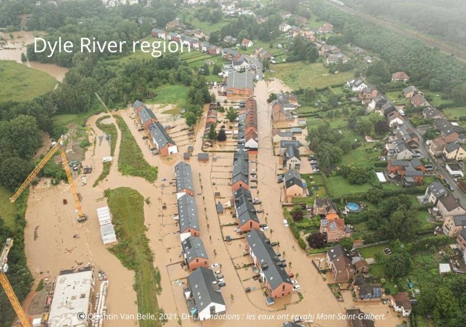
Dyle River, Belgium
The portion of the Dyle watershed under study is situated in the province of Walloon Brabant, to the south of Brussels in Belgium.
The Dyle River cuts through the Central Belgian plateau to form four main valleys and thousands of dry valleys, which concentrate runoff. This creates a hilly countryside with loamy soils that are very prone to muddy floods. Downhill, all the valleys have been densely urbanised historically, close to heavily farmed uphill plateaus. In short, the Dyle River basin is very sensitive to pluvial muddy floods and to floods by overflow due to the proximity of heavily urbanised areas built around water streams and very erodible fields.


Canche-Authie, France
The Canche-Authie river basin is located in northern France, on the chalk plateaus of southern Artois, and opens onto the Channel coast through the Canche and Authie estuaries. The area is characterized by a predominantly rural lowland landscape with gently undulating plateaus, incised river valleys and wide alluvial plains.
Land use mainly consists of intensive agriculture, with large arable fields and cropping systems
dominating the plateaus and gentle slopes. In the valley bottoms and coastal lowlands, meadows, pastures, wetlands, marshes, poplar plantations and riparian vegetation are present. Urban areas are limited to small towns, villages and scattered settlements, with more concentrated development near the estuaries and coastal fringe. The soils are mainly loamy and silty, developed on marly-chalk formations with loess, alluvial and peaty deposits. Although fertile, these soils are highly sensitive to compaction, runoff and erosion,especially on cultivated slopes. Combined with winter floods, groundwater rise and intense summer storms, these conditions make the basin particularly vulnerable to muddy floods, soil erosion and both riverine and coastal flooding.
Melsterbeek, Herk & Mombeek, Belgium
The Herk River basin is part of the greater Demer river basin and is roughly located in between the cities of Sint-Truiden, Hasselt and Tongeren, in the Belgian province of Limburg, in Flanders. The area is situated in the Belgian loam belt, which is characterized by an undulating landscape and loamy soils.
Land use
is primarily agricultural, with scattered villages. The valley consists mainly of old forests and pastures bordered by hedgerows. On the hillslopes and the plateau, we can find cropland and fruit plantations. Crops include wheat, corn, sugar beets and potatoes. The field parcels are large and the slopes can be steep in places. Combined with the presence of silt and silt loam soils, this area is particularly vulnerable to soil erosion. As a result, muddy floods in springtime are common, causing damage to houses in village centers, silting up ditches and rivers and damaging nature.


Kundelbach catchment, Germany
The Kundelbach catchment, part of the Ruwer basin, is located near the village of Kasel, in the Trier-Saarburg area of western Germany. The area is characterized by a narrow valley landscape shaped by the Ruwer river and its tributaries, with steep slopes and a strong influence of Devonian slate bedrock.
Land use mainly consists of agriculture, viticulture, forestry and scattered settlement. The land cover includes vineyards on the hillslopes, landscaped green spaces, water bodies, shrubs and mixed forests along the valley sides. Artificial surfaces are limited to the rural village of Kasel and its infrastructure. The upper soil substrates mainly consist of terrace sands near Kundelbach and loess-rich pelitic slate in general. Soils are mainly composed of rigosols in vineyards and cambisols with signs of temporary waterlogging, with textures ranging from sandy loam to loamy sand. Combined with intense rainfall, these conditions make the area particularly vulnerable to flood events, rapid runoff and soil erosion.